文章信息
- 李振洪, 宋闯, 余琛, 肖儒雅, 陈立福, 罗慧, 戴可人, 葛大庆, 丁一, 张宇星, 张勤
- LI Zhenhong, SONG Chuang, YU Chen, XIAO Ruya, CHEN Lifu, LUO Hui, DAI Keren, GE Daqing, DING Yi, ZHANG Yuxing, ZHANG Qin
- 卫星雷达遥感在滑坡灾害探测和监测中的应用:挑战与对策
- Application of Satellite Radar Remote Sensing to Landslide Detection and Monitoring: Challenges and Solutions
- 武汉大学学报·信息科学版, 2019, 44(7): 967-979
- Geomatics and Information Science of Wuhan University, 2019, 44(7): 967-979
- http://dx.doi.org/10.13203/j.whugis20190098
-
文章历史
收稿日期: 2019-02-15

2. 长安大学地质工程与测绘学院, 陕西 西安, 710064;
3. 河海大学地球科学与工程学院, 江苏 南京, 211100;
4. 长沙理工大学电气与信息工程学院, 湖南 长沙, 410014;
5. 国防科技大学电子科学学院, 湖南 长沙, 410073;
6. 成都理工大学地质灾害防治与地质环境保护国家重点实验室, 四川 成都, 610059;
7. 成都理工大学地球科学学院, 四川 成都, 610059;
8. 中国国土资源航空物探遥感中心, 北京, 100083;
9. 应急管理部国家减灾中心, 北京, 100124;
10. 中华人民共和国民政部, 北京, 100006
2. College of Geological Engineering and Geomatics, Chang'an University, Xi'an 710064, China;
3. School of Earth Science and Engineering, Hohai University, Nanjing 211100, China;
4. College of Electrical and Information Engineering, Changsha University of Science and Technology, Changsha 410014, China;
5. College of Electronic Science, National University of Defense Technology, Changsha 410073, China;
6. State Key Laboratory of Geohazard Prevention and Geoenviroment Protection, Chengdu University of Technology, Chengdu 610059, China;
7. College of Earth Sciences, Chengdu University of Technology, Chengdu 610059, China;
8. China Areo Geophysical Survey & Remote Sensing Center for Natural Resource, Beijing 100083, China;
9. National Disaster Reduction Center of China, Ministry of Emergency Management of China, Beijing 100124, China;
10. Ministry of Civil Affairs of the People's Republic of China, Beijing 100006, China
滑坡是一种自然界普遍存在的、由外部因素(如强降雨)或者构造运动触发的斜坡失稳滑落的地质现象[1-4],与地震、火山活动类似,可引起严重的地质灾害。世界范围内滑坡每年可造成重大人员伤亡和财产损失,据统计,仅在2004-2016年,滑坡灾害就造成近6万人死亡[5]。中国山区的滑坡灾害也非常严重,如在2017-06-24,四川省茂县地区突发体积达1 300万m3的特大山体滑坡,造成10人死亡,73人失踪。由此可见,滑坡减灾意义重大。为了降低滑坡灾害对山区人民人身财产安全的威胁,研究滑坡运动特征、准确探测潜在滑坡区域并对重点区域进行实时监测刻不容缓。
滑坡的活动特征受滑动位置、滑动速度和滑动强度的控制,在空间尺度和时间尺度上存在较大差异[6]。空间尺度可从集中于单个斜坡的局部尺度至数百km2的区域尺度[7]。时间尺度上的发展可划分为3个阶段[8-9]:①随时间推移应变率降低的初级蠕变阶段;②以缓慢运动为特征但易受外部因素驱动而速率变化的2级蠕变阶段;③位移加速直至滑坡发生的3级蠕变阶段。前两个阶段的运动速率较慢(小于0.4 m/d)[10-11],采样间隔为每周或者每月的观测数据即可记录其形变特征。而第3个阶段的运动速率变化较大,对观测数据的时间分辨率要求更高,需要达到每天、每小时甚至更高频率的观测。依据Cruden等[12]对滑动速度的划分,通常可以将滑坡具体划分为7个类别,其对应的物理破坏与人类损失程度如表 1所示[12-13]。在全球许多山区,特别是人口增长和基础设施发展较快的地区,滑坡容易发展为灾害,并造成人员和财产损失[14]。
| 类别 | 描述 | 典型速度 | 物理破坏 | 人类损失 |
| 1 | 超快 | >5 m/s | 滑坡造成暴力性灾难,例如建筑物摧毁 | 滑动物质或滑动块体分解的效应会造成人员损失 |
| 2 | 很快 | >5 m/min | 建筑物的重大毁坏 | 滑动速率很快,使得有些人来不及逃离,从而造成人员损失 |
| 3 | 快速 | >1 m/h | 建筑物和设备遭到破坏 | 人员撤离及疏散是可能的 |
| 4 | 中速 | >10m/month | 滑坡体前的临时性建筑可以在短期内不受到破坏,但滑坡上的建筑物会被严重破坏 | 全部人员撤离及疏散是可能的,伤亡可能只来自滑坡的次生效应,如建筑物倒塌 |
| 5 | 慢速 | >1 m/a | 如果偶发性的滑动不大,可以实施一些补救措施来维护临时性建筑设施 | |
| 6 | 很慢 | >10 mm/a | 这种滑动对一些永久性建筑物不会造成破坏 | |
| 7 | 超慢 | < 10 mm/a | 这种形变如果不用仪器测量是难以发觉的,可采取预防措施 |
滑坡探测通常是指在某一时刻对空间维上的潜在滑坡区域或者突发性滑坡的识别,而滑坡监测则侧重于在时间维上对已知或潜在滑坡的连续观测。传统的滑坡探测手段包括野外调查配合光学卫星影像[15-16]、岩土工程监测传感器[17-18]、雨量计[19]、地震仪[20]以及全站仪[21]等。其中,野外调查无法探测和监测人迹罕至的悬崖和陡坡上的滑坡。传统的岩土工程监测传感器包括张力计、测斜仪、应变仪和压力计等,可以测量滑坡块体内部的形变值;然而,其监测网络的构建通常耗时耗力,特别是对于新探测出的滑坡的监测[22],往往需要耗费巨大的时间与人力成本。此外,岩土工程监测是点测量方式,测量结果可能无法反映整个滑坡块体的形变特征[23]。雨量计和地震仪观测是针对由强降雨或地震引发的滑坡监测,无法用于其他类型的滑坡监测。传统全站仪依赖人工操作,无法自动作业,难以实现长期连续监测;现代全站仪可以自动化操作,但对观测条件(如测站间通视等)要求很高。全球导航卫星系统(global navigation satellite system, GNSS)观测手段可以在某种程度上弥补传统监测手段的不足,提升滑坡形变监测的精度和稳定性[24],但由于其点测量特性,也很难获取滑坡面的整体形变特征。总体来看,传统监测手段工作效率相对偏低,人工干预的成本较高,很难大范围高精度量化滑坡,特别是对于缓慢变形的滑坡体,其监测面临更大的挑战。
星载合成孔径雷达(synthetic aperture radar, SAR)对地观测技术可以克服上述观测手段的不足,提供监测区域高分辨率地表形变信息,实现滑坡的空间大范围探测和长周期精密监测[6, 14, 25-26]。相比光学图像,雷达影像可以提供强度和相位两种观测值,为滑坡的探测与监测提供新的高精度量化技术手段。利用合成孔径雷达干涉(interferometric SAR, InSAR)及时间序列分析技术,可以测量出mm/a级的地表形变速率,这对于探测缓慢蠕变的滑坡极为有利。基于此,星载雷达遥感技术近十多年在滑坡探测与监测中取得了长足的发展和应用[27-30],如利用高相干像素点时序分析技术获取很慢-超慢速率的滑坡体地表形变时空演化[31-34],利用SAR像素偏移量追踪测量和距离向分频干涉测量等技术获取中-慢速率的滑坡体地表形变[35-36]。
让人欣喜的是,星载雷达遥感在滑坡探测和监测方面的潜力与应用前景已经逐渐被科研学者及相关应用部门和单位认可,尤其是2017年四川茂县新磨村滑坡,可以说是一个重要的转折点。但需要指出的是,与传统测量技术类似,星载雷达遥感技术也有其与生俱来的局限性。就滑坡探测和监测而言,受限于滑坡复杂的地形环境和运动状态,例如SAR成像的质量通常与成像几何模式相关,而SAR影像的干涉测量又容易受植被、大气信号或地形效应的影响;此外,对于大梯度形变的滑坡,传统干涉测量难以捕捉其形变信号。为了充分明确成像雷达对地观测在探测和监测滑坡方面的优势和不足,本文总结了其面临的4类主要挑战,并简要给出了相应的应对措施,希望统一InSAR和滑坡研究学者对星载成像雷达对地观测技术优势及其限制条件的认识,进一步深化其在滑坡探测和监测方面的应用和推广。
1 挑战一:干涉去相干干涉相干性反映了雷达重复观测时回波信号的相似程度,是评价干涉相位观测量不确定性的直接指标[37-38]。导致干涉相位相干性降低的因素,如由地表密集植被覆盖引起的后向散射在重复成像时发生较大变化或由滑坡、地震等引起的大梯度形变等,称为去相干噪声。去相干噪声是制约InSAR测量精度的瓶颈,甚至导致无法获取有用的地表形变信号。本节针对滑坡区经常面临的密集植被覆盖和大梯度形变导致的去相干性问题,给出了相应的应对措施。
1.1 密集植被覆盖植被对相干性的影响大小与雷达波长、SAR影像空间分辨率及时空基线直接相关,因此在密集植被覆盖的山区,需要考虑采用合适的数据和方法以提高干涉影像的相干性。常用的方法有以下4种:
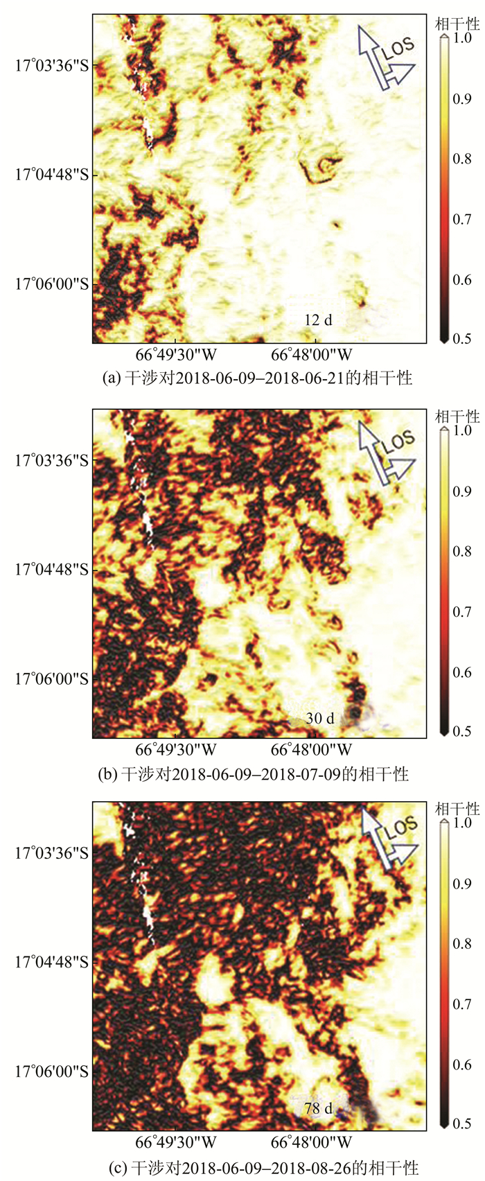
1) 选用成像时间间隔较短的SAR数据集。通过提高SAR数据集的时间分辨率,可以降低主副影像间地物变化的显著性,从而获取具有更高相干性的干涉对(见图 1)。
|
| 图 1 不同时间分辨率的SAR影像干涉对在玻利维亚滑坡体区域的相干性 Fig. 1 Coherence of SAR Image Pairs with Different Time Intervals in the Bolivia Landslide Area |
2) 使用波长较长的SAR系统数据。雷达波长越长,穿透能力越强,成像过程中受植被覆盖的影响也越小[39]。因此,使用波长较长的SAR系统数据,如S或L波段SAR影像,可以增强雷达波对植被的穿透性,从而提升干涉相位质量。
3) 选用高空间分辨率的SAR影像。具有更高空间分辨率的SAR影像,如COSMO-SkyMed和TerraSAR-X卫星条带模式或聚束模式数据,由于单位分辨单元内的影像质地更为单一,因此能够在一定程度上提升干涉对的相干性[36]。
4) 增强型InSAR时间序列分析。在由密集植被覆盖导致的低相干区,联合分布式散射体目标增加观测数、增强信噪比[40],让尽可能多的区域恢复形变信息,这是现有SAR影像条件下可行性最强、发展性最好的解决措施。代表性的技术包括SBAS(small baseline subset)[41]和Squee-SARTM[31]方法等。从某种意义上来说,Squee-SARTM也可被视为放宽了干涉对的选取条件,利用全干涉组合(N景SAR影像有N(N-1)/2个干涉对)相位信息进行形变反演的SBAS特例。两者同属相位滤波,但又有不同。SBAS一般采用空间滤波以提高相位质量,而SqueeSARTM选取与中心像元具有相同分布的统计同质像元参与平均,提升相位信噪比,更能保持图像的空间分辨率;SBAS是从滤波后的干涉相位中直接提取信息,而SqueeSARTM则通过对干涉序列的统计特征进行最大似然估计得到优化后的时序相位,再融入传统PSInSARTM框架获取形变时序等参数;从数据处理顺序而言,SBAS通常需要先对干涉对作相位解缠,再利用最小二乘或奇异值分解方法从非缠绕相位中恢复形变序列信息,而SqueeSARTM则是先进行相位优化得到缠绕的相位序列,可以采取预先滤波去除噪声影响,提高相位的信噪比,进而提升相位解缠的精度。
基于ENVISAT ASAR影像,应用增强型InSAR时间序列分析方法,成功探测出三峡库区巴东县的两个滑坡体,其形变速率达到10~15 mm/a[25]。基于分布式散射目标干涉测量的汶川震区文家沟巨型滑坡形变监测应用与分析表明,该滑坡区的大部分区域保持相对稳定,其平均形变速率小于5 mm/a[42],文家沟泥石流治理工程效果显著。
1.2 大梯度形变InSAR的本质是相位测量,当相邻像元间相位差超过π(即1/2周期)时,难以有效监测。这类超过临界相位梯度的形变一般称为大梯度形变,会引起干涉影像的失相干[43],因此传统InSAR技术无法用于快速滑动的滑坡监测。实践中,通常利用波长较长的SAR数据,如S波段或L波段的SAR系统因其波长大于C波段和X波段,单个干涉条纹可记录更大的形变,且因为同一形变区域的干涉条纹相对稀疏,有利于相位解缠。但多数情况下,即使采用L波段的SAR干涉影像也不足以测量大梯度形变。SAR像素偏移量追踪测量和距离向分频干涉测量(range split-spectrum interferometry, RSSI)方法可以用来测量大梯度的地表形变,虽然其监测精度较传统InSAR方法偏低。
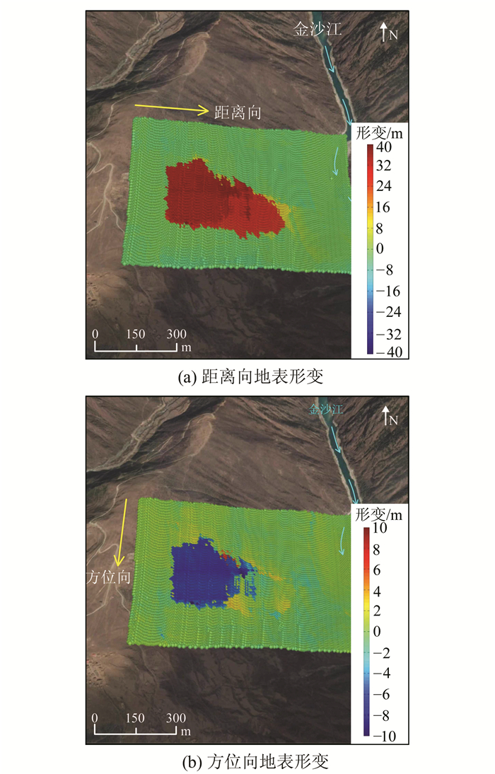
SAR像素偏移量追踪测量方法是基于影像配准后的SAR强度影像,逐像素计算主影像和副影像的互相关系数最大的窗口中心像素点的偏移量,并生成SAR像素偏移量图。Singleton等[36]利用此方法处理了2009-03至2010-04的TerraSAR-X卫星聚束和条带模式数据,成功监测了三峡地区树坪滑坡的形变情况。监测结果表明,此方法测量得到的角反射器上的形变大小与张力计[44]和GNSS同时期的观测结果相符[45],从而验证了该方法的准确性。利用该方法对2018年金沙江白格滑坡的滑前形变进行分析,如图 2所示,由2017-07-24和2018-07-23的SAR影像对分别在距离向和方位向测量到近40 m和10 m的形变,结果证明了SAR像素偏移量追踪测量方法探测高速率滑坡体的能力。
|
| 图 2 金沙江白格滑坡滑前的距离向和方位向形变 Fig. 2 Pre-failure Displacements Along the Range and Azimuth Directions of the Baige Landslide, the Jinsha River |
RSSI是另一种可以测量大梯度形变的方法,其原理是SAR成像频带的下部干涉图和上部干涉图之间的相位差可以反映两幅SAR影像之间的像素偏移量。具体处理过程为:首先将配准后的主影像和副影像分别进行带通滤波,然后分别对上频带和下频带的主副影像进行差分干涉,之后将自适应滤波后的上下频带干涉图进行复共轭相乘得到RSSI干涉图。在对RSSI干涉图进行相位解缠和非局部平均滤波后,即得到RSSI相位图。该方法已经被应用于强震形变监测[46]和滑坡监测[35]。相比传统的InSAR技术,RSSI的不足在于对地表形变的敏感性弱,因此在小梯度形变区域的监测精度较低。为了综合RSSI和传统InSAR的优势,Luo等[47]使用RSSI相位结果辅助解缠InSAR干涉图,主要流程为:首先将RSSI相位转换为初始InSAR相位,并与InSAR缠绕的干涉图进行复共轭相乘去除一阶地表形变,从而降低相位梯度;然后对得到的残余干涉图进行相位解缠,并将初始InSAR相位加至解缠后的残余相位图中,得到完整的解缠相位图;最后利用初始SAR波长将相位图转换为视线向位移图。该方法已成功应用于内蒙古唐家会煤矿的形变监测中,结果显示,该方法综合了RSSI测量大梯度形变和传统InSAR测量小梯度形变的优势[47],未来可将其应用于具有大梯度形变的滑坡探测和监测中。
2 挑战二:大气干扰卫星雷达发射的电磁波信号穿过地球大气层时会产生电离层延迟和对流层延迟。其中,电离层延迟和大气电离层的电子活跃程度有关,在赤道和两极地区相对显著,其量级大致与载波信号频率的平方成反比,在干涉影像上表现为大尺度长波信号,当探测与监测滑坡体等空间尺度较小的地物时,其影响通常可以忽略。在电离层活动异常的区域,波长较长波段的卫星雷达干涉影像中的电离层延迟可通过分频及线性组合的技术手段予以消除[48]。
对流层延迟与载波信号的频率无关,在量级上可达5~20 cm(取决于影像范围),且在时间和空间上相关性强、变化幅度大,与真实形变信号难以分离,甚至可以完全覆盖微小的地表形变。由于水汽及温度等空间上的分层效应,对流层延迟在干涉影像上表现出显著的与地表起伏有关的相关性,在山区或高原地区尤为明显。除此之外,不规则的大气对流运动也会引起随机性较强的对流层延迟信号,在空间上表现为聚集的团状、波状或完全随机、离散的形状。与高程相关的规则信号和不规则的扰动信号耦合在一起交互影响,难以用统一的模型建模,严重影响卫星雷达相位观测值及速率反演的精度。考虑到滑坡一般地处山区,与地形相关的对流层延迟尤为显著。如果附近存在河流、湖泊等水体,或监测期间存在强对流天气,大气的扰动信号更不容忽视。因此,在利用卫星雷达观测值进行滑坡探测、监测时,合理有效的干涉影像大气改正必不可少。
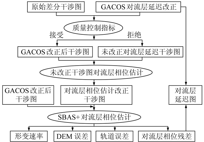
英国纽卡斯尔大学开发的通用型卫星雷达大气改正系统(generic atmospheric correction online service for InSAR, GACOS)具有全球可用、近实时及可提供一系列质量控制指标的特性[49],能够无缝融入雷达影像的自动化处理,在大范围滑坡探测中具有明显优势。在卫星雷达时间序列数据处理中,按照图 3所示的流程,利用GACOS系统对所有干涉影像进行改正,根据其提供的质量控制指标,挑选出改正效果欠佳的干涉对。此时可综合利用已改正和未改正的干涉对采用小基线组合的方法估计未被改正的干涉对的对流层延迟[50],达到所有影像全部改正的目的。经过改正后,对流层延迟在时间上的相关性被打破,干涉影像的残余误差更接近于高斯分布,从而利用传统的小基线算法可实现时间和空间上的高效滤波以提取高精度的速率信息,同时还可估计生成数字高程模型(digital elevation model,DEM)误差、轨道误差以及残余的对流层延迟。利用GACOS辅助的InSAR时间序列分析方法可广泛用于滑坡形变长期监测及缓慢速率反演中。
|
| 图 3 GACOS辅助的InSAR时间序列分析流程图 Fig. 3 Flowchart of InSAR Time Series Analysis Assisted by GACOS |
由于SAR采用侧视成像方式,波束斜向照射地表时会导致雷达图像中的距离压缩和阴影现象。距离压缩是雷达图像中的目标在距离向的几何失真现象,如图 4中的AC在雷达图像中被压缩为A′C′,DE、HG、HI、IJ都存在被压缩的现象,而AB更是被压缩为一个点A′B′。透视收缩是距离压缩的一种,主要是指面向雷达波束的斜坡投影到斜距平面时所出现的压缩,如斜面AB和DE。当视线向与坡面垂直时,会出现最大的透视收缩,如AB。叠掩是另一种特殊的距离压缩,当山顶回波比山脚部分回波更早被雷达接收时,会在距离向上造成山顶和山底影像倒置的现象,如坡面HG在雷达图像中表现为G′H′。叠掩现象与地形坡度和局部俯角有关,坡度β越大或俯角θ越大,发生叠掩的可能性越大。阴影是指在地形起伏区,由于后坡坡度α较大而使得雷达波束无法照射到斜坡背后区域,从而在强度图像上产生阴影区,如图 4中的条纹三角区ΔGIJ。阴影区不含信息,但却是一种很好的观测方向和地形信息的指示器。
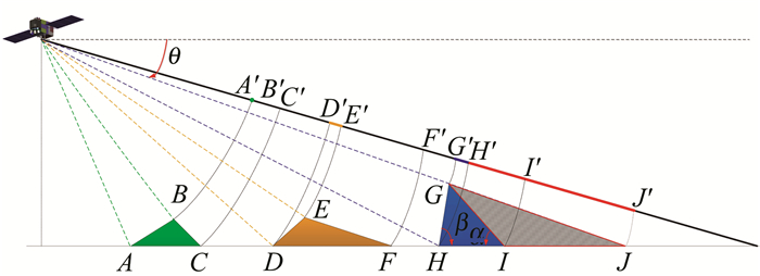
|
| 图 4 SAR成像的几何关系示意图 Fig. 4 Schematic Diagram of SAR Imaging Geometry |
针对SAR成像几何带来的阴影和叠掩问题,可采用以下3种方式来应对:
1) 若能结合升降轨SAR影像、具有不同入射角的多轨道影像和不同卫星平台的SAR影像,则可以获取不同成像几何下的监测目标的形变特征,从而在一定程度上补偿单一成像几何带来的叠掩和阴影等问题。
2) 借助外部DEM及SAR系统几何参数,可以生成该区域的阴影和叠掩区,从而在滑坡探测过程中作预先处理,节省处理时间,这种方法一般适合自动化处理低分辨率的SAR影像。
3) 借助机器学习算法对阴影和叠掩区进行端对端高精度提取,从而在利用时间序列InSAR进行滑坡探测时能进行掩膜处理,提高InSAR相位解缠的精度和效率。
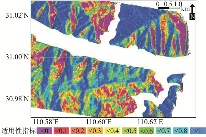
3.2 SAR适用性分析SAR系统在卫星轨道方向的灵敏性很低,对于坡向与成像方位向相近的滑坡,应用InSAR难以测量其沿坡向的运动[51]。因此,在使用InSAR进行滑坡探测和监测之前,需要明确其在目标区域的适用性。基于滑坡体沿南北方向的变形在LOS(line of sight)向投影很小的假设前提,利用目标区域DEM计算得到的坡度、坡向及SAR入射角、航向角等信息,可以计算不同成像模式下SAR系统在该区域的适用性指标[52]。图 5显示的是利用30 m空间分辨率SRTM DEM和TerraSAR-X聚束模式影像的成像几何参数计算的三峡地区TerraSAR-X探测滑坡的适用性。适用性按0至1被划分为10个类别,数值越高代表SAR影像在该区域的适用性越强。这种量化的适用性指标可以为SAR在滑坡探测和监测中的应用提供重要参考。其中,滑坡探测处理过程中的预先处理,能够明确哪个区域可用哪种卫星影像探测得到,哪些区域无法用星载雷达遥感技术获得,从而制定相应的措施。
在InSAR干涉影像中,阴影区和水体区为低相干区,而叠掩区的相位也不同于正常的InSAR相位。这些区域若不能检测出来并进行掩膜或者内插处理,则会对相位解缠带来较大误差,从而影响滑坡探测精度。目前,已有一些研究人员对水体、阴影和叠掩区的提取进行了研究,并取得了一定成果。Song等[54]针对高山地区的洪水提出了一个高精度的水体分类方法,其中用到了RadarSat-1图像、灰度共生矩阵及地形信息;王健等[55]提出了一种结合InSAR相干系数图、Sigma滤波和最优阈值分割算法来提取SAR阴影的方法;Papson等[56]提出了一种基于隐马尔可夫模型的分类系统对目标的阴影区进行建模和分类;任云等[57]提出了一种结合SAR图像干涉幅度和相干系数的算法来识别阴影和叠掩区;魏恋欢等[58]提出了基于Butterworth滤波的奇异值分解层析算法来提取叠掩区域。此外,可以直接利用DEM及SAR系统几何参数产生该区域的阴影和叠掩区[59]。在低分辨率SAR影像中,该方法提取的阴影和叠掩区可直接在InSAR时间序列中被掩膜,进而完成滑坡探测;但在高分辨率SAR影像中,该方法获取的阴影和叠掩区准确度不高,直接使用会影响后续滑坡探测精度。水体、阴影和叠掩区的提取可利用机器学习方法,建立新的网络结构,实现水体、阴影和叠掩区3种目标的端对端高精度提取。图 6显示的是基于航天2院23所的机载多天线毫米波系统的SAR数据,利用深度学习网络结构对不同目标分开训练产生认知模型,进而测试产生的水体、阴影区域及叠掩区域并提取结果。水体、阴影和叠掩的提取精度分别达到86%、87%和78%。
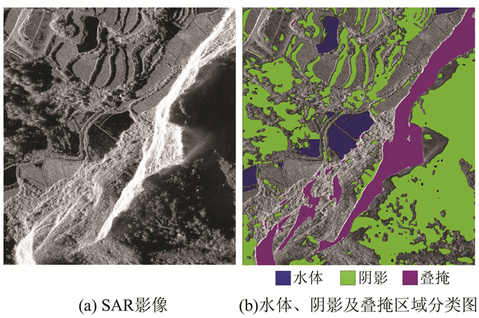
|
| 图 6 SAR影像与水体、阴影及叠掩区域分类图 Fig. 6 SAR Image and Classification Result of Water, Shadow and Layover Areas |
地形相位是干涉相位中的重要组成成分,InSAR形变测量的精度在一定程度上依赖于地形相位估计与去除的准确性。在地表起伏较大的区域,例如城市的高建筑物和自然陡坡,若空间基线较长,则干涉相位可能不连续,造成相位解缠非常困难,一般称为地形效应。为了有效去除地形相位,除了卫星参数满足一定的精度要求外,要求DEM数据与SAR数据具有相近的分辨率和像元大小,确保两类数据的空间尺度统一。在中低分辨率(20~30 m)的InSAR应用中,现有的30 m/90 m空间分辨率的SRTM数据已能满足地形相位去除的实际需求。在高分辨率的InSAR应用场景下,如1~3 m分辨率的TerraSAR-X、COSMO-SkyMed卫星数据,现有免费的DEM,但其空间分辨率较低,限制了地形相位的去除效果。由于SAR卫星的空间侧视几何,SAR图像中相邻的点(斜距相近)实际上分别对应建筑物顶端以及地面点(城市高楼)或斜坡顶部与底部的点(自然陡坡)。这两点由于高程上的巨大差异,在由中等空间基线构成的干涉相位上往往也会产生巨大跳变(大于π)。在相位解缠时,传统方法往往认为相邻点的相位是连续的,由此会产生相位解缠误差。以深圳宝安为例,其光学图像如图 7(a)所示,图 7(b)是垂直基线为110 m的干涉图。利用30 m SRTM DEM进行地形效应去除后,不考虑残余地形相位的影响而直接利用StaMPS方法[60-61]进行相位解缠,结果如图 7(d)所示,可见由于未能有效去除地形相位,楼顶与地面的相位被看成是连续的,因此出现了明显的解缠误差。
为了应对地形效应这一挑战,出现了一系列相位解缠方法。如统计估计法,包括最大后验概率法(maximum a posteriori, MAP)与最大似然法(maximum likelihood, ML)。在ML方法中,Shabou等[62]所提出的多通道相位幅度正则化方法,利用图像分割优化,成功进行了DEM重建与相位解缠,克服了多通道相位解缠[63-64]时间消耗长与内存占用大的缺点,但其零形变及统计独立的干涉图假设在实际情况中很难满足。Shabou等[65]利用MAP与马尔可夫随机场克服了高度不连续带来的干扰并抑制了噪声,但由于其计算量巨大,故限制了其应用。而非统计方法,包括最小费用流(minimum cost flow,MCF)、卡尔曼滤波(Kalman filter,KF)以及聚类分析(cluster analysis,CA)等,都具有相位解缠能力。拓展的最小费用流(extended MCF,EMCF)方法[66-67]是利用时间/垂直基线平面与方位/距离平面,形成两个Delaunay三角网,从而进行相位解缠,但其对形变模型与地形误差的先验知识提出了要求。扩展的KF方法利用空间连续性检测及后处理步骤[68]克服了高程不连续的限制,但其无形变以及与距离相关的高程梯度假设可能与实际不符。CA方法[69-70]首先将所有的像素点分成不同的组,再分别找出每一组的模糊向量,从而进行相位解缠;虽然其避免了模型假设,但利用N维搜索来获取模糊向量,计算量大且容易出错,同时需要大量的像素点来保证其准确性,故CA法也有缺陷。
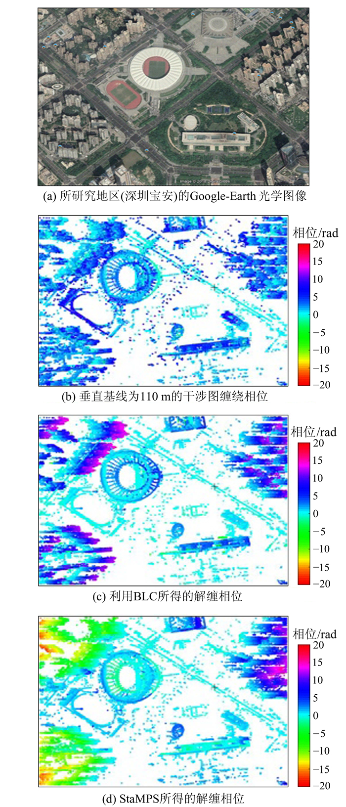
|
| 图 7 StaMPS方法与BLC方法的相位解缠结果对比 Fig. 7 Comparison of Phase Unwrapping Results of StaMPS and BLC Methods |
地形相位去除不完全的问题可通过BLC(baseline linear combination)方法予以解决。该方法将干涉图进行线性组合,形成近零基线的干涉图,并组成新的等效干涉时间序列,从而最大限度地降低DEM误差所带来的影响。BLC方法无需对形变模型进行先验假设,采用时间1维+空间2维的方法进行相位解缠,在得到时间解缠相位后,使用空间网络法进行空间相位解缠。以Delaunay三角网为基础,根据空间连续性条件剔除/添加新的“绝对相位差小于π边”,并进行空间积分,从而以较小的计算量和较稳健的空间连接方式得到空间的相位解缠结果。图 7(c)给出了BLC方法在深圳宝安区域的解缠结果,对比StaMPS方法得到的相位解缠结果(图 7(d)),可见二者在SAR几何上地形缓慢变化的区域,具有相近的解缠结果;而在地形迅速变化的区域,如左上角楼顶与地面的叠掩区域,BLC方法能检测到相位的跳变,从而进行正确的解缠,而StaMPS方法由于未考虑相位突变的情况,解缠结果出现错误。BLC方法可用于滑坡探测和监测中,通过提高相位解缠的准确性,从而更精细地获取滑坡形变特征,特别是对于高差较大的滑坡体。
5 展望与对策在未来发展计划中,德国、意大利、中国、日本等均提早规划出了新一代卫星的发射计划,雷达成像卫星硬件发展将迎来前所未有的“黄金时期”。随着新一代SAR卫星(如Sentinel-1、ALOS-2、TerraSAR-X等)所获取的影像质量的显著提高(空间分辨率越来越高,重访周期越来越短)[71],同一研究区域可获取多平台、多波段、多入射角的卫星数据。多数据融合必将成为发展趋势,能够在一定程度上解决干涉去相干与几何畸变的问题[72]。面对海量数据情况下,如何实现快速响应的数据获取、存储、查询与分发共享是需要重视的问题。同时,需顾及不同数据处理技术对不同形变速率、不同观测对象的适用性差异,如InSAR适用于缓慢形变的滑坡监测,而像素偏移量技术适用于慢速至中速的滑坡监测,相关处理技术的选择也至关重要,特别是当未来的应用中拥有足量的、不同的SAR数据时。从用户层面来讲,随着星载雷达遥感技术的普及以及卫星成像质量的提升,研究成果将更多地进入公众的视野。科研学者、其他行业专家、工程单位普通工作人员以及社区民众都将可能成为终端用户,针对不同用户需求发布不同级别的用户产品,也是未来需要关注的方面。
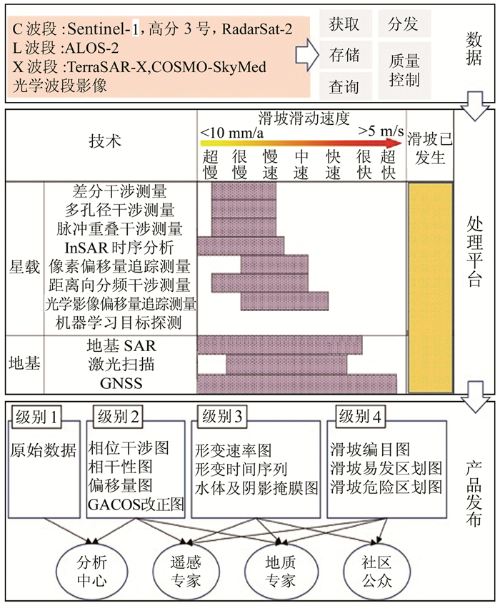
因此,为实现“研究原理,发现隐患,监测隐患,发布预警”的目标,亟需构建一套以星载雷达为主、光学影像为辅并结合地面观测手段的滑坡探测与监测系统。综合前文星载雷达的4大挑战与未来发展趋势,本文提议的滑坡探测/监测系统框架如图 8所示,分为3个平台:
|
| 图 8 基于多源对地观测的滑坡探测/监测系统的基本框架 Fig. 8 Basic Framework of a Landslide Detection/Monitoring System Based on Multi-source Earth Observations |
1) 数据平台。含数据获取、存储、查询和分发等功能,该平台将多源的雷达和光学影像收集入库,并做好质量控制。
2) 处理平台。综合目前的卫星雷达观测技术和滑坡类别,仅仅使用星载雷达影像还无法全类别、全方位地探测和监测滑坡。图 8给出了不同对地观测技术(包括星载平台和地基平台)所能探测到的滑坡类别。对于滑动速度在中速及以下的滑坡,卫星雷达观测可以实现探测和监测;但对于滑动速度在快速及以上的滑坡,必须借助地基对地观测手段如地基SAR和GNSS等进行监测。而对于已经发生的滑坡,可以利用机器学习方法快速探测滑坡体,其他技术亦可发挥功能,为灾后快速反应提供决策支持。在滑坡的探测和监测中,目前最大的难点在于如何综合利用这些观测手段实现滑坡的自动化探测和全尺度监测。滑坡的自动化探测要求自动调整不同的观测技术,以确保不将滑坡体遗漏于卫星雷达影像的去相干区或者噪点区,而滑坡的全尺度监测要求综合现有的对地观测技术进行互补式监测,例如将GNSS接收机架设在InSAR监测盲区。
3) 产品发布平台。该平台对不同的用户有不同的权限和相应的产品。目前,对雷达遥感数据的自动化处理与滑坡探测/监测系统的需求显著,但解译结果的好坏在一定程度上还取决于解译人员的经验和专业水平,因此不同类别、不同层次的产品需要“用户化”。滑坡分析中心可以获取低级别的原始数据和干涉影像等产品,遥感和地质专家可以获得干涉影像、时间序列分析结果和滑坡编目/易发区/危险区划图等产品,而公众一般可获得滑坡风险评估的终端产品,亦可根据需要获取滑坡区形变产品。
对于滑坡等自然灾害的防控需要运用多技术手段才能最大程度地保障人民的生命财产安全。而在这个过程中,InSAR和地质灾害领域专业人才的培养也至关重要。过去30年间,星载SAR系统和InSAR数据处理技术都得到了迅猛发展,但由于其涉及多学科综合,解译结果需要专家经验等,技术门槛相对较高。目前,中国仅有数10所高校、科研院所在测绘、遥感、电子类等学科的研究生阶段培养相关人才,人才匮乏也在一定程度上限制了InSAR技术的推广和应用。加大相关领域人才的培养力度,应该引起学界的广泛关注。
| [1] |
Highland L, Bobrowsky P T. The Landslide Handbook: A Guide to Understanding Landslides: Posted November 2008[EB/OL]. https://pubs.usgs.gov/circ/1325/pdf/C1325_508.pdf, 2008
|
| [2] |
Hu X, Wang T, Pierson T C, et al. Detecting Seasonal Landslide Movement Within the Cascade Landslide Complex (Washington) Using Time-Series SAR Imagery[J]. Remote Sensing of Environment, 2016, 187: 49-61. DOI:10.1016/j.rse.2016.10.006 |
| [3] |
Iverson R M. Landslide Triggering by Rain Infiltration[J]. Water Resources Research, 2000, 36(7): 1 897-1 910. DOI:10.1029/2000WR900090 |
| [4] |
Malamud B D, Turcotte D L, Guzzetti F, et al. Landslides, Earthquakes, and Erosion[J]. Earth and Planetary Science Letters, 2004, 229(1-2): 45-59. DOI:10.1016/j.epsl.2004.10.018 |
| [5] |
Froude M J, Petley D. Global Fatal Landslide Occurrence from 2004 to 2016[J]. Natural Hazards and Earth System Sciences, 2018, 18: 2 161-2 181. DOI:10.5194/nhess-18-2161-2018 |
| [6] |
Peyret M, Djamour Y, Rizza M, et al. Monitoring of the Large Slow Kahrod Landslide in Alborz Mountain Range (Iran) by GPS and SAR Interferometry[J]. Engineering Geology, 2008, 100(3-4): 131-141. DOI:10.1016/j.enggeo.2008.02.013 |
| [7] |
Thiebes B. Landslide Analysis and Early Warning Systems: Local and Regional Case Study in the Swabian Alb, Germany[M]. Berlin, Heidelberg: Springer Science & Business Media, 2012.
|
| [8] |
Stähli M, Sättele M, Huggel C, et al. Monitoring and Prediction in Early Warning Systems for Rapid Mass Movements[J]. Natural Hazards and Earth System Sciences, 2015, 15(4): 905-917. DOI:10.5194/nhess-15-905-2015 |
| [9] |
Xu Q, Yuan Y, Zeng Y, et al. Some New Pre-warning Criteria for Creep Slope Failure[J]. Science China Technological Sciences, 2011, 54(1): 210-220. |
| [10] |
International Union of Geological Sciences Working Group on Landslides. A Suggested Method for Describing the Rate of Movement of a Landslide[J]. Bulletin of the International Association of Engineering Geology, 1995, 52(1): 75-78. DOI:10.1007/BF02602683 |
| [11] |
Metternicht G, Hurni L, Gogu R. Remote Sensing of Landslides: An Analysis of the Potential Contribution to Geo-Spatial Systems for Hazard Assessment in Mountainous Environments[J]. Remote Sensing of Environment, 2005, 98(2-3): 284-303. DOI:10.1016/j.rse.2005.08.004 |
| [12] |
Cruden D M, Varnes D J. Landslides: Investigation and Mitigation. Chapter 3-Landslide Types and Processes[J]. Transportation Research Board Special Report, 1996, 247: 91-105. |
| [13] |
Society A G. Landslide Risk Management Concepts and Guidelines[J]. Australian Geomechanics, 2000, 35(1): 49-92. |
| [14] |
Tazio S, Jan K, Holger F, et al. Satellite SAR Interferometry for the Improved Assessment of the State of Activity of Landslides: A Case Study from the Cordilleras of Peru[J]. Remote Sensing of Environment, 2018, 217: 111-125. DOI:10.1016/j.rse.2018.08.014 |
| [15] |
Casson B, Delacourt C, Allemand P. Contribution of Multi-temporal Remote Sensing Images to Characterize Landslide Slip Surface-Application to the La Clapière Landslide (France)[J]. Natural Hazards and Earth System Sciences, 2005, 5(3): 425-437. DOI:10.5194/nhess-5-425-2005 |
| [16] |
Mondini A, Guzzetti F, Reichenbach P, et al. Semi-automatic Recognition and Mapping of Rainfall Induced Shallow Landslides Using Optical Satellite Images[J]. Remote Sensing of Environment, 2011, 115(7): 1 743-1 757. DOI:10.1016/j.rse.2011.03.006 |
| [17] |
Corominas J, Moya J, Lloret A, et al. Measurement of Landslide Displacements Using a Wire Extensometer[J]. Engineering Geology, 2000, 55(3): 149-166. DOI:10.1016/S0013-7952(99)00086-1 |
| [18] |
Uhlemann S, Smith A, Chambers J, et al. Assessment of Ground-Based Monitoring Techniques Applied to Landslide Investigations[J]. Geomorphology, 2016, 253: 438-451. DOI:10.1016/j.geomorph.2015.10.027 |
| [19] |
Martelloni G, Segoni S, Fanti R, et al. Rainfall Thresholds for the Forecasting of Landslide Occurrence at Regional Scale[J]. Landslides, 2012, 9(4): 485-495. DOI:10.1007/s10346-011-0308-2 |
| [20] |
La Rocca M, Galluzzo D, Saccorotti G, et al. Seismic Signals Associated with Landslides and with a Tsunami at Stromboli Volcano, Italy[J]. Bulletin of the Seismological Society of America, 2004, 94(5): 1 850-1 867. DOI:10.1785/012003238 |
| [21] |
Artese S, Perrelli M. Monitoring a Landslide with High Accuracy by Total Station: A DTM-Based Model to Correct for the Atmospheric Effects[J]. Geosciences, 2018, 8(2): 46. |
| [22] |
Barla M, Antolini F. An Integrated Methodology for Landslides' Early Warning Systems[J]. Landslides, 2016, 13(2): 215-228. DOI:10.1007/s10346-015-0563-8 |
| [23] |
Casagli N, Catani F, del Ventisette C, et al. Monitoring, Prediction, and Early Warning Using Ground-Based Radar Interferometry[J]. Landslides, 2010, 7(3): 291-301. DOI:10.1007/s10346-010-0215-y |
| [24] |
Wang G Q. Kinematics of the Cerca Del Cielo, Puerto Rico Landslide Derived from GPS Observations[J]. Landslides, 2012, 9(1): 117-130. DOI:10.1007/s10346-011-0277-5 |
| [25] |
Liu P, Li Z, Hoey T, et al. Using Advanced InSAR Time Series Techniques to Monitor Landslide Movements in Badong of the Three Gorges Region, China[J]. International Journal of Applied Earth Observation and Geoinformation, 2013, 21: 253-264. DOI:10.1016/j.jag.2011.10.010 |
| [26] |
Tomás R, Li Z, Liu P, et al. Spatiotemporal Characteristics of the Huangtupo Landslide in the Three Gorges Region (China) Constrained by Radar Interferometry[J]. Geophysical Journal International, 2014, 197(1): 213-232. DOI:10.1093/gji/ggu017 |
| [27] |
Dai K, Li Z, Tomás R, et al. Monitoring Activity at the Daguangbao Mega-Landslide (China) Using Sentinel-1 Tops Time Series Interferometry[J]. Remote Sensing of Environment, 2016, 186: 501-513. DOI:10.1016/j.rse.2016.09.009 |
| [28] |
Dong J, Liao M, Xu Q, et al. Detection and Displacement Characterization of Landslides Using Multi-temporal Satellite SAR Interferometry: A Case Study of Danba County in the Dadu River Basin[J]. Engineering Geology, 2018, 240: 95-109. DOI:10.1016/j.enggeo.2018.04.015 |
| [29] |
Hilley G E, Bürgmann R, Ferretti A, et al. Dynamics of Slow-Moving Landslides from Permanent Scatterer Analysis[J]. Science, 2004, 304(5 679): 1 952-1 955. |
| [30] |
Zhao C, Kang Y, Zhang Q, et al. Landslide Identification and Monitoring Along the Jinsha River Catchment (Wudongde Reservoir Area), China, Using the InSAR Method[J]. Remote Sensing, 2018, 10(7): 993. DOI:10.3390/rs10070993 |
| [31] |
Ferretti A, Fumagalli A, Novali F, et al. A New Algorithm for Processing Interferometric Data-Stacks: SqueeSAR[J]. IEEE Transactions on Geoscience and Remote Sensing, 2011, 49(9): 3 460-3 470. DOI:10.1109/TGRS.2011.2124465 |
| [32] |
Ferretti A, Prati C, Rocca F. Permanent Scatterers in SAR Interferometry[J]. IEEE Transactions on Geoscience and Remote Sensing, 2001, 39(1): 8-20. DOI:10.1109/36.898661 |
| [33] |
Hooper A. A Multi-temporal InSAR Method Incorporating Both Persistent Scatterer and Small Baseline Approaches[J]. Geophysical Research Letters, 2008, 35(16): L16302. DOI:10.1029/2008GL034654 |
| [34] |
Hooper A, Zebker H, Segall P, et al. A New Method for Measuring Deformation on Volcanoes and Other Natural Terrains Using InSAR Persistent Scatterers[J]. Geophysical Research Letters, 2004, 31(23): L23611. |
| [35] |
Shi X, Jiang H, Zhang L, et al. Landslide Displacement Monitoring with Split-Bandwidth Interferometry: A Case Study of the Shuping Landslide in the Three Gorges Area[J]. Remote Sensing, 2017, 9(9): 937. DOI:10.3390/rs9090937 |
| [36] |
Singleton A, Li Z, Hoey T, et al. Evaluating Sub-pixel Offset Techniques as an Alternative to D-InSAR for Monitoring Episodic Landslide Movements in Vegetated Terrain[J]. Remote Sensing of Environment, 2014, 147: 133-144. DOI:10.1016/j.rse.2014.03.003 |
| [37] |
Touzi R, Lopes A, Bruniquel J, et al. Coherence Estimation for SAR Imagery[J]. IEEE Transactions on Geoscience and Remote Sensing, 1999, 37(1): 135-149. DOI:10.1109/36.739146 |
| [38] |
Jiang M, Ding X L, Li Z W. Hybrid Approach for Unbiased Coherence Estimation for Multitemporal InSAR[J]. IEEE Transactions on Geoscience and Remote Sensing, 2014, 52(5): 2 459-2 473. DOI:10.1109/TGRS.2013.2261996 |
| [39] |
Rosen P A, Hensley S, Zebker H A, et al. Surface Deformation and Coherence Measurements of Kilauea Volcano, Hawaii, from Sir-C Radar Interferometry[J]. Journal of Geophysical Research: Planets, 1996, 101(E10): 23 109-23 125. DOI:10.1029/96JE01459 |
| [40] |
Jiang Mi, Ding Xiaoli, Li Zhiwei. Homogeneous Pixel Selection Algorithm for Multitemporal InSAR[J]. Chinese Journal of Geophysics, 2018, 61(12): 4 767-4 776. (蒋弥, 丁晓利, 李志伟. 时序InSAR同质样本选取算法研究[J]. 地球物理学报, 2018, 61(12): 4 767-4 776. ) |
| [41] |
Berardino P, Fornaro G, Lanari R, et al. A New Algorithm for Surface Deformation Monitoring Based on Small Baseline Differential SAR Interferograms[J]. IEEE Transactions on Geoscience and Remote Sensing, 2002, 40(11): 2 375-2 383. DOI:10.1109/TGRS.2002.803792 |
| [42] |
Tang Y, Zhang Z, Wang C, et al. The Deformation Analysis of Wenjiagou Giant Landslide by the Distributed Scatterer Interferometry Technique[J]. Landslides, 2018, 15(2): 347-357. DOI:10.1007/s10346-017-0917-5 |
| [43] |
Massonnet D, Feigl K L. Radar Interferometry and Its Application to Changes in the Earth's Surface[J]. Reviews of Geophysics, 1998, 36(4): 441-500. DOI:10.1029/97RG03139 |
| [44] |
Wang F, Yin Y, Huo Z, et al. Slope Deformation Caused by Water-Level Variation in the Three Gorges Reservoir, China[M]//Sassa K, Rouhban B, Briceño S, et al. Landslides: Global Risk Preparedness. Berlin, Heidelberg: Springer, 2013
|
| [45] |
Liao M, Tang J, Wang T, et al. Landslide Monitoring with High-Resolution SAR Data in the Three Gorges Region[J]. Science China Earth Sciences, 2012, 55(4): 590-601. DOI:10.1007/s11430-011-4259-1 |
| [46] |
Jiang H, Feng G, Wang T, et al. Toward Full Exploitation of Coherent and Incoherent Information in Sentinel-1 Tops Data for Retrieving Surface Displacement: Application to the 2016 Kumamoto (Japan) Earthquake[J]. Geophysical Research Letters, 2017, 44(4): 1 758-1 767. |
| [47] |
Luo H, Li Z, Chen J, et al. Integration of Range Split Spectrum Interferometry and Conventional InSAR to Monitor Large Gradient Surface Displacements[J]. International Journal of Applied Earth Observation and Geoinformation, 2019, 74: 130-137. DOI:10.1016/j.jag.2018.09.004 |
| [48] |
Gomba G, Parizzi A, de Zan F, et al. Toward Operational Compensation of Ionospheric Effects in SAR Interferograms: The Split-Spectrum Method[J]. IEEE Transactions on Geoscience and Remote Sensing, 2016, 54(3): 1 446-1 461. DOI:10.1109/TGRS.2015.2481079 |
| [49] |
Yu C, Li Z, Penna N T, et al. Generic Atmospheric Correction Model for Interferometric Synthetic Aperture Radar Observations[J]. Journal of Geophysical Research: Solid Earth, 2018, 123(10): 9 202-9 222. DOI:10.1029/2017JB015305 |
| [50] |
Li Z, Fielding E J, Cross P. Integration of InSAR Time-Series Analysis and Water-Vapor Correction for Mapping Postseismic Motion After the 2003 Bam (Iran) Earthquake[J]. IEEE Transactions on Geoscience and Remote Sensing, 2009, 47(9): 3 220-3 230. DOI:10.1109/TGRS.2009.2019125 |
| [51] |
Cascini L, Fornaro G, Peduto D. Advanced Low-and Full-Resolution DInSAR Map Generation for Slow-Moving Landslide Analysis at Different Scales[J]. Engineering Geology, 2010, 112(1-4): 29-42. DOI:10.1016/j.enggeo.2010.01.003 |
| [52] |
Notti D, Meisina C, Zucca F, et al. Models to Predict Persistent Scatterers Data Distribution and Their Capacity to Register Movement Along the Slope[C]. The Fringe 2011 Workshop, ESRIN, Frascati, Italy, 2011
|
| [53] |
Singleton A G. Analysing Landslides in the Three Gorges Region (China) Using Frequently Acquired SAR Images[D]. Glasgow: University of Glasgow, 2014
|
| [54] |
Song Y S, Sohn H G, Park C H. Efficient Water Area Classification Using RadarSat-1 SAR Imagery in a High Relief Mountainous Environment[J]. Photogrammetric Engineering & Remote Sensing, 2007, 73(3): 285-296. |
| [55] |
Wang Jian, Xiang Maosheng, Li Shaoen. A Method for Extracting the SAR Shadow from InSAR Cohe-rence[J]. Geomatics and Information Science of Wuhan University, 2005, 30(12): 1 063-1 066. (王健, 向茂生, 李绍恩. 一种基于InSAR相干系数的SAR阴影提取方法[J]. 武汉大学学报·信息科学版, 2005, 30(12): 1 063-1 066. ) |
| [56] |
Papson S, Narayanan R M. Classification via the Shadow Region in SAR Imagery[J]. IEEE Transactions on Aerospace and Electronic Systems, 2012, 48(2): 969-980. DOI:10.1109/TAES.2012.6178042 |
| [57] |
Ren Yun, Zou Huanxin, Qin Xianxiang, et al. A Method for Layover and Shadow Detecting in InSAR[J]. Journal of Central South University (Sicence and Technology), 2013, 44(S2): 396-400. (任云, 邹焕新, 秦先祥, 等. 一种InSAR叠掩与阴影区域的检测方法[J]. 中南大学学报(自然科学版), 2013, 44(S2): 396-400. ) |
| [58] |
Wei Lianhuan, Liao Mingsheng, BALZ Timo, et al. Layover Building Scatterers Extraction via High-Resolution Spaceborne SAR Tomography[J]. Geomatics and Information Science of Wuhan University, 2014, 39(5): 536-540. (魏恋欢, 廖明生, BALZ Timo, 等. 高分辨率SAR层析成像建筑物叠掩散射体提取[J]. 武汉大学学报·信息科学版, 2014, 39(5): 536-540. ) |
| [59] |
Kropatsch W G, Strobl D. The Generation of SAR Layover and Shadow Maps from Digital Elevation Models[J]. IEEE Transactions on Geoscience and Remote Sensing, 1990, 28(1): 98-107. DOI:10.1109/36.45752 |
| [60] |
Hooper A. A Statistical-Cost Approach to Unwrapping the Phase of InSAR Time Series[C]. International Workshop on ERS SAR Interferometry, Frascati, Italy, 2010
|
| [61] |
Hooper A, Zebker H A. Phase Unwrapping in Three Dimensions with Application to InSAR Time Series[J]. Journal of the Optical Society of America A, 2007, 24(9): 2 737-2 747. DOI:10.1364/JOSAA.24.002737 |
| [62] |
Shabou A, Baselice F, Ferraioli G. Urban Digital Elevation Model Reconstruction Using Very High Resolution Multichannel InSAR Data[J]. IEEE Transactions on Geoscience and Remote Sensing, 2012, 50(11): 4 748-4 758. DOI:10.1109/TGRS.2012.2191155 |
| [63] |
Ferraioli G, Shabou A, Tupin F, et al. Multichannel Phase Unwrapping with Graph Cuts[J]. IEEE Geoscience and Remote Sensing Letters, 2009, 6(3): 562-566. DOI:10.1109/LGRS.2009.2021165 |
| [64] |
Ferraiuolo G, Pascazio V, Schirinzi G. Maximum a Posteriori Estimation of Height Profiles in InSAR Imaging[J]. IEEE Geoscience and Remote Sensing Letters, 2004, 1(2): 66-70. DOI:10.1109/LGRS.2003.822882 |
| [65] |
Shabou A, Tupin F. A Markovian Approach for DEM Estimation from Multiple InSAR Data with Atmospheric Contributions[J]. IEEE Geoscience and Remote Sensing Letters, 2012, 9(4): 764-768. DOI:10.1109/LGRS.2011.2181326 |
| [66] |
Pepe A, Lanari R. On the Extension of the Minimum Cost Flow Algorithm for Phase Unwrapping of Multitemporal Differential SAR Interferograms[J]. IEEE Transactions on Geoscience and Remote Sensing, 2006, 44(9): 2 374-2 383. DOI:10.1109/TGRS.2006.873207 |
| [67] |
Pepe A, Yang Y, Manzo M, et al. Improved EMCF-SBAS Processing Chain Based on Advanced Techniques for the Noise-Filtering and Selection of Small Baseline Multi-look DInSAR Interferograms[J]. IEEE Transactions on Geoscience and Remote Sensing, 2015, 53(8): 4 394-4 417. DOI:10.1109/TGRS.2015.2396875 |
| [68] |
Ambrosino R, Baselice F, Ferraioli G, et al. Extended Kalman Filter for Multichannel InSAR Height Reconstruction[J]. IEEE Transactions on Geoscience and Remote Sensing, 2017, 55(10): 5 854-5 863. DOI:10.1109/TGRS.2017.2716185 |
| [69] |
Liu H, Xing M, Bao Z. A Cluster-Analysis-Based Noise-Robust Phase-Unwrapping Algorithm for Multibaseline Interferograms[J]. IEEE Transactions on Geoscience and Remote Sensing, 2015, 53(1): 494-504. DOI:10.1109/TGRS.2014.2324595 |
| [70] |
Yu H, Li Z, Bao Z. A Cluster-Analysis-Based Efficient Multibaseline Phase-Unwrapping Algorithm[J]. IEEE Transactions on Geoscience and Remote Sensing, 2011, 49(1): 478-487. DOI:10.1109/TGRS.2010.2055569 |
| [71] |
Dai Keren. Integration of New Generation SAR Data for Extracting the Earth's Surface Topography and Displacement: Methodology and Modelling[D]. Chengdu: Southwest Jiaotong University, 2017 (戴可人.融合新一代卫星SAR数据的地形与形变信息提取模型与方法[D].成都: 西南交通大学, 2017)
|
| [72] |
Wasowski J, Bovenga F. Investigating Landslides and Unstable Slopes with Satellite Multi Temporal Interferometry: Current Issues and Future Perspectives[J]. Engineering Geology, 2014, 174: 103-138. DOI:10.1016/j.enggeo.2014.03.003 |
 2019, Vol. 44


